
How can an underwater robot estimate its path when satellite navigation is unavailable and cameras cannot see far enough due to murky water? Researchers have developed ISOPoT, a method that estimates vehicle motion from a sequence of sonar images.
The method was presented in the paper ISOPoT: Imaging Sonar Odometry by Point Tracking, published in IEEE Robotics and Automation Letters. The authors are Jaša Samec, Vid Rijavec, Prof. Danijel Skočaj, and Dr. Matej Dobrevski from the Faculty of Computer and Information Science, University of Ljubljana, together with Marko Peljhan, Dr. Aleksander Grm, and Dr. Andrej Androjna. The research was conducted in collaboration with the University of Ljubljana Faculty of Maritime Studies and Transport, the company TIMTEC, and the University of California, Santa Barbara.
Sonar perceives its surroundings using sound waves, allowing observation even in poor visibility conditions. However, sonar images contain significant noise, distortions, and only a small number of clearly recognizable features. As a result, existing approaches that estimate motion by matching points between pairs of images are often not reliable enough in such environments.
ISOPoT addresses this challenge differently. Instead of comparing only image pairs, it tracks selected points across multiple consecutive sonar images and estimates the vehicle’s movement from their trajectories. The method employs modern machine-learning models originally developed for point tracking in conventional videos. Additional procedures for selecting reliable points and refining motion estimates help reduce the impact of incorrect matches.
The researchers evaluated the method on the publicly available Aracati 2017 dataset and on their own Portorož 2025 dataset, collected in a real marine environment. The results showed that ISOPoT achieved more accurate motion estimates than existing approaches, both when using only sonar images and when combining them with additional sensors. Its performance was particularly strong in environments with few distinctive features, where traditional feature-matching methods tend to struggle.
These findings represent an important step toward more reliable navigation of autonomous underwater vehicles. Such methods could facilitate marine exploration, seabed mapping, and underwater infrastructure inspection, especially in conditions where camera-based systems are limited.
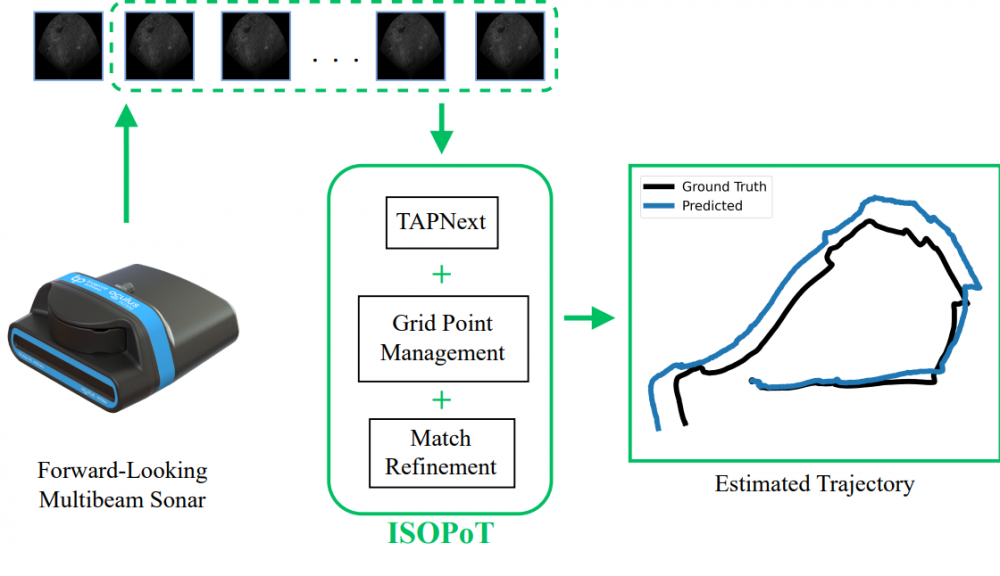
Figure: The method takes a sequence of sonar (acoustic) images as input and uses a deep neural network to track selected points throughout the sequence. It then employs a second neural network to further refine point correspondences between consecutive images. Based on these refined correspondences, the method estimates the motion of the underwater vehicle and reconstructs its trajectory.